SEVERE Tropical Cyclone Sean formed north of the Pilbara Coast on 19 January producing persistent showers, destructive winds and severe storms around northern parts of the Western Australian coast.
A low-pressure system off the coast of New South Wales brought several days of severe storms and widespread heavy rainfall to the coast during the week.
Cold fronts and associated troughs during the week brought scattered showers and storms to southern parts of Western Australia and South Australia, eastern New South Wales, Victoria, and Tasmania.
Persistent low-pressure troughs through the interior, eastern states and Western Australia produced storms, some severe, and scattered rainfall in these regions.
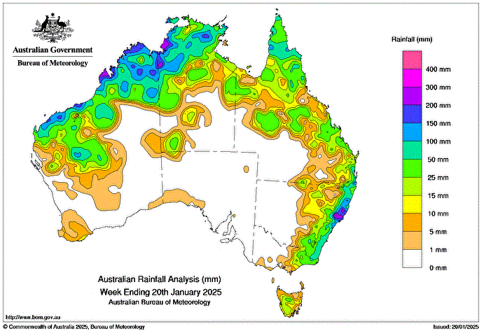
Weekly rainfall totals greater than 25 mm were recorded across northern and western parts of the Northern Territory, northern Western Australia, Queensland’s north and east, eastern New South Wales and Victoria, and central Tasmania.
Weekly rainfall totals of 50 to 100 mm were recorded across northern parts of Western Australia and the Northern Territory, parts of Queensland’s north and south-east, eastern New South Wales and an isolated pocket of eastern Victoria.
Weekly rainfall totals greater than 100 mm were recorded along the northern and central regions of the New South Wales coast, northern areas of Western Australia, and the Northern Territory, and isolated parts of Queensland’s north.
The highest weekly total (at a Bureau gauge) was 503.8 mm at Careys Peak (Barrington Tops) in New South Wales, which included the highest daily total rainfall of 281.0 mm in 24 hours to 9 am on 18 January.
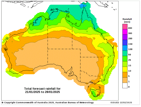
8 day Rainfall Forecast
HAVE YOUR SAY